
The annual Coast to Coast is an annual New Zealand
multisport race. Starting on the West
coast, 140KM of scenic road biking is punctuated by an iconic 30KM mountain run
and 70KM river paddle which includes a committing white water gorge. Where else can you race across a country in a
day? The race is a bucket list event for
all adventure athletes. Most people get
to the finish line never wanting to see another bike saddle, kayak or energy
bar in their life. Alex got to the
finish line and said: it’d be a lot more bloody interesting if it was mountain
biking and had less support. Fast
forward six years and I’m about to find out if that bold statement holds true.
We have given ourselves three days to complete
our inaugural traverse from Hokitika on the West Coast of NZ to Rakaia Huts on
the East Coast of NZ. Hours of pouring
over maps and countless emails back and forth had sketched out a pretty
appetising route: mountain biking almost entirely dirt road or single track, a
hike across an epic NZ pass with packrafts which would then deliver us down
some classic East Coast braided rivers.
Our leader for this trip was Alex, a long-time companion in adventure
and the man responsible for kicking off this madness. We were joined by Scott, big hearted and
happy-go-lucky kiwi who also happened to be hard as nails and a central figure
in NZ adventure and brevet scene. And
then there was me, possibly best described at present as a desk jockey and
family man from Canberra, looking to relive some past adventures and escape the
real world for a while.
DAY 1
After some early morning childcare and bike
packing logistics, Alex’s wife, Ann-Marie dropped us in Hokitika at 1PM on
Friday to begin. This first leg was on
mountain bikes and set us on our eastward trajectory, following the West Coast
Wilderness Trail towards Lake Kaniere.
We decided on a slight detour that was well worth it, despite adding
some technical single track, elevation (ie climbing stairs) and time to our
journey. To our right, the lush west
coast rainforest closed in with overhanging ferns, slippery roots from old
knurled trees and vivid green mossy rocks all vying for our attention. To our left, the hand-dug Kaniere Water Race
built in 1875, was still delivering a constant gurgle of crystal clear water
from the lake to the valley below.
Postcard idyllic doesn’t quite do the area justice, as I made a mental
note to return and explore the area when I had a bit more time up my sleeve.
Before we knew it 45KM had flown past and
we popped out of the rainforst to the banks of Lake Kaniere, eager to embark on
the second phase of the journey. This
leg took us up the Styx Valley and over Browning pass to the headwaters of the
Wilberforce River. So, we swapped our
bikes for packs laden with packrafts, paddles, PFDs, helmets and enough food
for 36 hours. We had mentally prepared
for 40 – 60km on foot, depending on where we were able to launch the pack
rafts.
We set off in high spirits. For the next four hours we splashed across
creeks and meandered our way through the lush undergrowth, the mighty Styx
River rumbling away in the background.
After witnessing the power of the river and the size of some of the
rapids, we quickly concluded that it wasn’t a river that we would be
packrafting anytime soon!
With the sun fading, we started mulling
over our options for the night. We knew
that care was required when traversing Browning Pass from West to East, so we
were hesitant about crossing this in the dark. We opted for a solid night’s
rest at Harman Hut and an early start so we would reach the pass at first
light.
This decision was quickly validated when we
came across the sign at the turn off to Browning’s Pass: “Warning:
Browning’s Pass descent is EXTREMELY steep.
Take EXTREME caution when descending”. When you come across a tramping sign in NZ
which has EXTREME in capitals, twice, I figured it was best to take
notice. This is not Australia where a
sign like this would likely mean a 5m section of hand rail was missing on a wide
concrete pass crossing a gentle grass covered 45 degree slope.
By now we had left the river valley and
entered into classic alpine terrain, gaining solid altitude as we traversed the
sides of some impressive peaks. By 10.30PM
we had found Harman Hut, were contentedly munching away on a late dinner and
looking forward to a few hours’ sleep in comfort. As we all bedded down for the night I realised
I had made a rookie error, taking some electrolytes that contained caffeine
earlier in the evening. As someone who
doesn’t regularly have caffeine, I was now trapped in the maddening situation
of a very weary body, over active mind and the constant reminder that the alarm
would be going off in a few short hours.
A tough lesson to have to relearn as Scott and Alex snored contentedly
in their bunks.
DAY 2
At 4AM the alarm went off. On cue, and with a few primitive grunts,
headlights went on, sleeping bags were peeled back and packed, warm thermals
were fondly parted with, Gurney Goo was liberally applied to a wide variety of
body areas and on went the damp clothes, wet socks and wet shoes from the
previous day. Canned fruit, tuna and muesli
bars went down the hatch and by 4.25AM we were wading through the first stream
of the day, alone in the little worlds created by the glow of our head torches. All this was, of course, done on auto pilot,
honed from many days on the trail and a few too many adventure races. It’s dangerous to think or ask question at
this time of the morning!
The relatively balmy pre-dawn tramp saw us
drop down into the river valley, before climbing 500 metres to Lake Browning. We lost the non-descript trail a few times as
we navigated up the boulder strewn river bed. Finally, we found an appropriate
place to cross, and starting to climb to the pass towering above.
Dawn was breaking by the time we hit the
pass. We found a sheltered spot on the
shore of Lake Browning and fired up the stove to have a proper warm
breakfast. The pre-dawn warmth disappeared
as the cloud rolled in and, combined with the altitude and exposure to the
wind, we quickly donned our jackets and balaclavas. While eating we were treated to glimpses of
the surrounding peaks, basking in the morning alpine glow. The wind whipped the
cloud across the pass and into the valley we were about to descend. We were all carrying helmets for the packrafting
leg and remembering the EXTREME descent we were about to embark on, strapped
them on as we headed off.
The pass was exposed, the track was very
narrow and very loose as it clung to the side of a 70 degree scree slope
stretching out below. EXTREME? Perhaps?
I would say it was fine unless you had issues with heights or put a foot wrong. Then you would be in trouble. It certainly wasn’t a place we wanted to
dwell and I noticeably felt the mental tension lifting as we dropped in
altitude towards the beginning of the braided river stretching out below us.
The following five hours passed rapidly as
the temperatures began to climb, a stiff headwind emerged and we bashed down
the river constantly checking water levels to gauge whether there was enough to
put the packrafts in. At around 1PM we
decided it was time, inflated the raft and with nervous excitement, set out on
the next phase of this adventure. There
would not usually be enough water this high on the Wilberforce River but, the
floods earlier in the season had left the river high and we enjoyed a solid
hour of running fast little rapids in fairly shallow water. A couple of surprisingly big wave trains
almost had us in for an early swim in the clear turquoise water and got us
excited about things to come.
Unfortunately, after this point the valley
widened from about 1km to 3km across. The river spread out too, dividing into
multiple braids while the headwind picked up.
This made for some very slow bottom scraping progress. After an hour of wading down countless calf-deep
rapids and having the rafts buffeted off-line with even with the most dedicated
paddling, we eventually gave up. Back into the packs they went and off we set
on foot with the aim of getting to the confluence where the Wilberforce River
meets the much bigger Rakaia River.
At about 8PM we found a nice sheltered spot
and decided to stop for some dinner and make some decisions. We still had about
two hours of walking before we reached the confluence, but the volume of the
Wilberforce had picked back up and looked much more promising for the
rafts. Should we keep walking tonight, or
wake up early and knock off the walk before sun up or risk putting in the pack
rafts here? After an action packed 16
hour day, we all decided that it was time to set up camp and leave the
remaining 2 hours of walking to the morning.
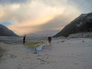
So up went to tarp, in came the sand flies and down went the sun,
turning the river braids incredible shades of pink and gold as it slipped below
the surrounding peaks.
DAY 3
At 4AM the alarm went off, again. No one moved.
Scott asked: why don’t I set it to 5AM and we can just risk packrafting
instead of walking? It was the best suggestion
I had heard for a while, so back to sleep we all drifted. 5AM bought no such reprieve as we swung into
action, with the packrafts ready for launch at first light.
The lazy call turned out to be the inspired
call. Water levels were high enough and
in no time at all, the turquoise clear Wilberforce water was lost into the
swiftly moving cloudy glacial melt of the Rakaia. We were now cruising along at a rapid clip,
with the speed and force of the river picking up as we moved towards Rakaia Gorge,
a 4KM stretch where the river is channelled between two imposing ridge lines
that exposed some beautifully stratified rock layers.
I should pause here and mention that I have
absolutely no experience in white water and was assured that we would
experience, at most, some easy grade two rapids that posed no danger at all. I’d been given the safety briefing on how to
navigate a rapid (head for the apex), what to avoid (rocks, holes, trees,
cliffs and jetboats!) and what to do if we went swimming (lie on your back,
feet downstream). Alex had limited
experience and with him steering at the back of our two person pack raft, I
trusted we would be in for some wholesome fun.
That notion began to get tested as some
more challenging waves and holes appeared. Scott found himself out of position and ploughed
straight into a hole, side on, getting a mighty bucking but incredibly staying
upright. As we watched on, laughing
nervously at his amazing luck, we found ourselves horribly offline and also
almost ended up also going for a swim as we were swept through a bigger than
anticipated set of waves.
By now we were in the Gorge proper and it
was somewhat disconcerting to hear Alex let out strings of expletives about
water features he’d never seen before and scream at me to PADDLE PADDLE PADDLE.
The rafts seemed to float across currents and get buffeted by invisible water
forces much more than traditional kayaks, which had both Alex and Scott
improvising as they went along. I just
hung on, paddled hard and did what I was told!
We finally emerged from the Gorge, dry and
shaken, but not stirred!. Packrafting the Gorge was best summed up, in much
less poetic terms, by expressing gratitude that we had taken a nature break
prior to entering it and thus, saved us some embarrassment in what was a bit of
a bowel moving experience.
We were met by Scott’s wife Jo with our
bikes and the ever important egg and bacon pie, bananas, fruit juice and
beers. The beers would have to wait as
we tenderly mounted our bikes for the last 65km that would broadly keep us
parallel with the Rakaia until it met the ocean. While the intent was to be on dirt roads and mountainbike
trail the whole way, we first needed to complete 5km of bitumen, before hitting
the back roads and farm tracks which would eventually deliver us to our
goal.
These tracks proved to be a bit tricker
than expected, with a thin covering of loose gravel and really only one smooth
line to ride within - about a truck tyre width across. The feeling of the front wheel sliding out
was enough to keep us all alert as we formed a pace-line to try and get the
last leg over and done with as quick as possible. By now our bodies were really aching, with
our feet, hands and bums having taking the brunt of the previous hike and pack
raft. There wasn’t much difference between
just cruising along or really pushing it, so we took turns at burying our heads
out in front into the slight head-wind and managed to maintain a solid 25km/h
pace.
Before we knew it, the sea was in sight and
we rolled into Rakaia Huts for the obligatory final photo, 215KM (check) and
74.45 hours after setting out. We packed
up the bikes quickly before all our strength faded, opened a beer and headed
off back to Christchurch with Jo. The
drive back was filled with the usual post-adventure buzz of contented
excitement that comes with being outdoors with a great bunch of people.
But it’s amazing how quickly your mind
transitions from the adventure back to reality.
The tranquillity that comes with unconsciously monitoring the direction
of the headwind, speed of the water under your raft and sureness of rocks under
your foot. The zen-like focus needed to propel you through these amazing
natural environments. This all evaporated
rapidly as the outskirts of Christchurch rolled by: plans for kids pick-up were
finalised, dinner needed preparing and I needed to get all my gear cleaned and
packed to make my 4.30AM check in for the flight back to Australia the next day.
THE
VERDICT
So, “a lot more bloody interesting than the
formal coast to coast race”? I don’t think anyone can deny the buzz and
kudos associated with finishing mass multisport events with hundreds, if not
thousands of like-minded individual. It is a high than can last for
days. However, I am increasingly finding myself drawn to the warm satisfaction
that comes with a crazy idea, a whole lot of uncertainty and a small group of
likeminded mates. It’s no surprise then that as my early flight climbed
above the Southern Alps, I was eyeing up the braided rivers and passes
unfolding below, piecing together the next off-road coast to coast adventure.
by Rob Tyson


by Rob Tyson


No comments:
Post a Comment